Tibradden Mountain
Tibradden Mountain is one of the more popular and manageable hikes on the Dublin Mountains Way, with relatively moderate slopes leading to a broad, flat summit, approximately 470m (1570 feet) above sea level. Despite its relatively modest height, hikers are rewarded with views spanning Dublin Bay and south of the city. The woods at the base of the mountain are part of a Coillte forestry plantation of Sitka Spruce, though patches of old pine woods planted in 1910 can still be seen. Heather, furze, gorse and bilberry grow in abundance and, if you’re lucky, you might catch a glimpse of sika deer, foxes or badgers. The upper slopes are covered with blanket bog, where it is possible to spot red grouse among the heather. The name Tibradden is thought to derive from Tigh Bródáin, meaning ‘Brodáin’s House’– a possible reference to the cairn on the summit.
The cairn is a small, circular mound of stones with an opened chamber and the remains of a short partially lintelled ‘passage’ which runs off the chamber to the north-north east. The monument was excavated by antiquarians in 1849 and subsequently reconstructed rather haphazardly so that its true form is difficult to discern. The 19th century ‘excavation’ revealed a central cist containing a bowl food vessel and cremation enclosed within a small circular chamber. The cairn was investigated again in 1956 as part of conservation works and interpreted as a Bronze Age cairn with centrally-placed cist burial. A secondary urn burial was found within the cairn.
It is possible that the cairn on Tibradden started as a Neolithic passage tomb, like the 11 others that crown the Dublin Mountains. Many Neolithic tombs across Ireland were reused and modified during the Bronze Age (and even later) periods. Perhaps the most famous example of that later reuse is the Mound of the Hostages (Duma na nGiall) on the Hill of Tara, where a Neolithic passage tomb was reused as an important burial site into the Bronze Age. The cairn on Tibradden offers clear views to the other cairns at Fairy Castle, on the summit of Two Rock Mountain, and over towards the Hellfire Club on the summit of Montpelier Hill, where presumably the cairns there would have been very visible before the construction of the Hunting Lodge.
Inside the chamber there is a stone bearing a spiral motif. Unfortunately rather than being megalithic art, it is thought to have been cut into the rock some time in the later 20th century, by someone inspired by Ireland’s megalithic art tradition.
For practical information about visiting this site Click Here

Aerial view of Tibradden Cairn on Tibradden Mountain • Dublin
The Burial Place of a Once Mighty King?
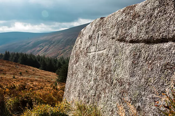
Tibradden Mass Rock with faint engravings [tap image to see markings highlighted] • Dublin
According to a story in the Schools Folklore Collection, the cairn is said to be the burial place of Niall Dhú, better known as Niall Glúndub, High King of Ireland from AD 916–919. He was the progenitor of the famed Uí Néill of Ulster, who were one of the most prominent powers of early medieval Ireland. Niall was a highly successful leader of war bands, and he became King of Aileach in AD 911. After a series of victories over rival kingdoms, he became the most prominent leader, being appointed as the High King of Ireland in AD 916.
However, almost as soon as he came to power Niall faced a dire threat, the Viking dynasty of Ívarr had returned to Dublin and Waterford in AD 917 and were smashing their way across Munster and Leinster. Niall’s reign was spent campaigning and fighting against the dangerous Ívarr Dynasty. He led the armies of Ulster and their allies south to fight in Munster. There were victories and defeats on both sides in a bloody and bruising series of battles. The Annals of Ulster describe Niall’s final fight at the Battle of Cill-Mosamhog. This was a devastating defeat, along with High King Niall Glúndub, a number of other Irish kings and leaders were slaughtered by the Vikings. Niall was the first High King to have been killed by the Vikings, and this momentous loss had shocking repercussions around Ireland. As described in the Annals of Ulster:
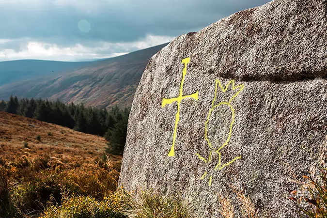
Tibradden Mass Rock with faint engravings (hover over or click the image to see a highlight) • Dublin
‘Mournful today is virginal Ireland
Without a mighty king in command of hostages;
It is to view the heaven and not to see the sun
To behold Niall’s plain without Niall…’
The name ‘Cill-Mosamhog’ has often been misidentified with Kilmashogue, leading to the legend of Niall being buried in the cairn here. However it is far more likely that Cill-Mosamhog was Kilmainham, and that the battle took place close to the main Viking stronghold there. Other accounts suggest that Niall was taken from the battlefield and buried at the monastery of Kells in County Meath. So it is unlikely that Niall was interred here, though it is a truly beautiful and suitably elevated place for such an important king.
Close to the cairn, around 80m to the south, a cross is inscribed on a rock outcrop. The cross is incised into the large granite rock, and displays expanded terminals. A crowned figure with upraised arms is also recorded at the site. The figure is said to be adjacent to the cross, though it is difficult to discern in poor light conditions. Given the isolated setting, it may represent a ‘Mass Rock’ from the 17th or 18th century, an altar for priests celebrating the then prohibited Catholic Mass. The isolated location would help them and their congregation to avoid the punitive Penal Laws.


Upper left: Tibradden Cairn • Lower left: The Mass Rock with an engraving of a cross. Beside the cross, but more faintly, is a figure with its arms raised and wearing a crown • Right: pathway on Tibradden Mountain
Top: Tibradden Cairn • Middle: pathway on Tibradden Mountain • Bottom: The Mass Rock with an engraving of a cross. Beside the cross, but more faintly, is a figure with its arms raised and wearing a crown
Tibradden Mountain Visitor Information
Tibradden Mountain has plenty of relatively easy trails and hikes and is also full of archaeology, folklore and natural heritage.